T. A. Co.
Tracking Animals and Conservation
Giuliano Colosimo 
T.A.Co. stands for Tracking Animals and Conservation. It began in 2015, while I was still working on my PhD on the population genetics of Caribbean iguanas. Colleagues in Rome had started looking for a way to monitor the critically endangered Galapagos pink land iguana, Conolophus marthae (Gentile, 2012), an animal that is almost impossible to watch. A decade later that question has turned into a line of work on building tracking devices for animals nobody would want to follow on foot.
Why movement is a conservation problem
Every conservation decision is, at bottom, a decision about space. Which hectares to protect, where to put a fence or remove a predator, where a translocated animal should be released, whether two populations are connected or effectively isolated. All of those need to know where animals actually go, not where we assume they go.
The framework I teach in my Animal Tracking course comes from Nathan et al. (2008), who argued that any movement path is produced by four things acting together: the animal’s internal state (why move?), its motion capacity (how to move?), its navigation capacity (when and where to move?), and the external factors it encounters. A tracking device records only the path. The whole craft lies in reasoning backwards from that path to the components that produced it, and in being honest about how far the data can carry you.
Done well, that reasoning yields the things managers actually ask for: home ranges and space use, which habitats an animal selects while resting and while travelling, when it switches between behavioural states, and whether a journey is a purposeful migration or a random walk that happens to look like one.
The hardest animal to watch
Conolophus marthae was described to science only in 2009 and listed as Critically Endangered in 2012 (Gentile, 2012). It exists as a single population on the north-western slope of Wolf Volcano, on Isabela Island, in an area of less than 25 km², with a census of roughly 200–300 individuals. No hatchlings have been recorded since 2005, which suggests recruitment has effectively stopped or at a minimum; introduced feral cats and black rats are the prime suspects. The species shares the volcano with its congener C. subcristatus, with which it does not hybridise but very likely competes.
The logistics are the other half of the problem. Wolf Volcano rises to about 1700 m and is roughly 150 km from the nearest village. Up to only a couple of years ago there was no infrastructure, no cellular network, and communication were possible only by UHF radio or satellite. A helicopter can cost up to $3000 an hour; the alternative is to hike, which means every litre of water, every battery and every drop of generator fuel is carried in by hand. A fieldwork station with basic infrastructure and commodities has been established in 2024, but, in practice, fieldwork lasting more than two or three weeks is unattainable (Loreti et al., 2020).
So the animal you most need to observe continuously is the one you can observe least. That gap is the whole justification for the project.
A tag that feeds itself
The first device was a GPS wireless sensor node designed around that constraint (Loreti et al., 2019). Because nobody is coming back to change a battery, it harvests its own energy: a small solar cell charging a supercapacitor, which then has to supply two of the hungriest things on the board: the GPS receiver and a high-current radio booster for long-range transmission.
Supercapacitors rather than lithium-ion was a deliberate choice, and an ecological one. These devices are deployed in a national park where the probability of never recovering a unit is real, so the hardware was designed to be as benign as possible if it is left behind. Alongside position, the node logs temperature, humidity and UVB, parameters that matter for a thermoregulating ectotherm, and that are far more meaningful measured on the animal than inferred from a distant weather station.
Knowing what the numbers mean
A device that reports a number is not the same as a device that reports a true number. The second paper was an honest audit of our own instrument (Loreti et al., 2020). It found that the protective casing biases both the temperature and the UVB readings, but that the bias is systematic, and so can be corrected with regressions calibrated under controlled conditions. GPS accuracy degrades under vegetation and with the tag’s orientation on a moving animal, yet still delivered an average error under 15 m in more than half of all fixes.
Publishing the limitations of your own hardware is less satisfying than publishing its successes, but it is what makes the data usable by anyone else.
From one iguana to twenty-two
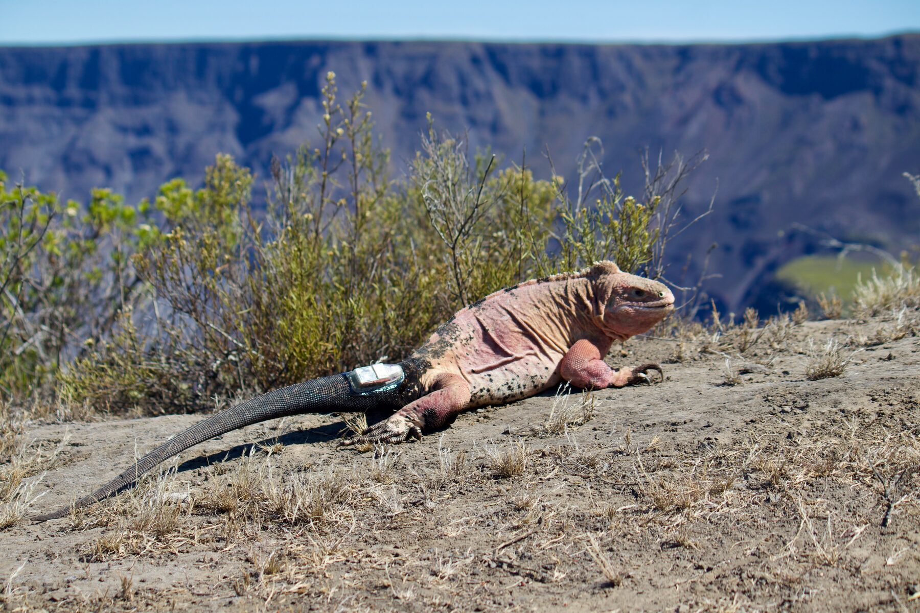
The first real test was a single animal. Between 25 September 2019 and 3 March 2020 (159 days) one adult male carried a node and kept reporting (Colosimo et al., 2022). Reconstructing his trajectory and analysing it with integrated step selection functions revealed an altitudinal shift of more than 1000 m, and showed the path was not random: directed movement, not wandering. A seasonal migration had been suspected in this species for fifteen years without ever being observed. One individual does not prove it for a species, and the paper said so plainly, but it turned a plausible story into a measured one.
Four years of tracking later, there is an answer. Twenty-two iguanas, seven males and fifteen females, were followed between 2019 and 2023 — work now in review, and available as a preprint (Gargano et al., 2026). Sixteen of the twenty-two migrate seasonally between a small mating area high on the volcano and a larger dispersal area below it, with males arriving at the mating ground about 48 days before females. That makes C. marthae a partially migratory species — some individuals move, others do not.
The more interesting question is why, and here the tracking data could discriminate between two competing explanations. The obvious one, that animals follow shifting peaks of food, does not survive contact with the evidence: the lower dispersal area turns out to be more productive than the mating area all year round. Temperature does not explain it either — the two areas differ by only about 2 °C. What remains is access to breeding sites: the animals climb because that is where they can reproduce, not because it is where the food is. That is a site-dependent migration, a pattern well described in birds and mammals and, until now, barely tested in reptiles.
Finding the nests
Movement data also solved a problem that had blocked conservation action outright. A head-start programme, rearing hatchlings in captivity past the age at which cats and rats kill them, was a priority in the species’ 2022–2027 conservation plan. But nobody knew where pink iguanas nested, and until 2021 not a single hatchling had ever been seen.
Working from the hypothesis that males and females should separate after mating, we modelled net displacement against day of year for animals tagged in April 2021, and looked for movement specific to females (Gargano et al., 2024). They had it. Females struck out for a small plateau inside Wolf Volcano’s caldera, roughly 400 m below the northern rim, and clustered there once they arrived.
That was enough to send rangers from the Galapagos National Park Directorate to the right few hectares. They located individual nests, and shortly afterwards sighted and collected the first hatchlings ever recorded for the species.
It is worth being plain about what that means. A tracking device did not save the species. But it converted an unanswerable question into a map reference, and in doing so it unblocked the single intervention most likely to keep C. marthae from going extinct. That is what the project is for.
The next generation
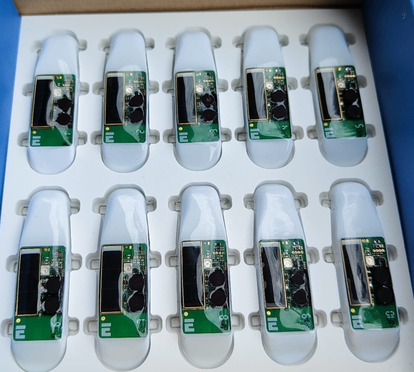
The current device is a different animal (Luca et al., 2025). It keeps the energy-harvesting and long-range LoRa architecture, but adds a sensor suite aimed at the animal rather than just its coordinates: atmospheric pressure, volatile compounds, solar irradiation from ultraviolet to infrared, a microphone and, most ambitiously, heart rate and respiration, inferred ballistocardiographically from an inertial sensor and validated against Doppler measurements. That physiological strand has become a project of its own, M.A.C.R.A.
The microphone is there for more than soundscape ecology. Acoustic monitoring can flag when an animal is near a road or human activity, and gunshot or voice detection is already used elsewhere to support anti-poaching patrols. A tag that hears as well as sees is a different kind of conservation instrument.
Why we do not publish the coordinates
One deliberate omission runs through all of this work: we do not release the exact GPS positions of individual pink iguanas. Precise locality data for a flagship critically endangered reptile is itself a conservation risk, and the trade in trafficked iguanas is well documented, including in work I have co-authored on how CITES permits are laundered through transit countries (Auliya et al., 2025). Data are available on reasonable and documented request to the senior authors.
People and funding
T.A.Co. is a collaboration between biologists and electronic engineers at the University of Rome Tor Vergata, with partners at the Galapagos National Park Directorate, the San Diego Zoo Wildlife Alliance, the Italian National Research Council, and the Cayman Islands Department of Environment. Recent development has been supported by the Darwin Plus Initiative and by the Italian National Recovery and Resilience Plan through the RESTART programme.
If you work on biologging, low-power embedded sensing, or reptile movement ecology, I am always glad to hear from you.